

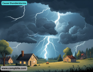
Cause thunderstorms Here’s a more detailed breakdown of how thunderstorms form, including the necessary conditions and processes:
Moisture & Instability
- An unstable atmosphere (where temperature drops rapidly with altitude) allows this air to keep rising.
Ice Particles & Electrical Charge
- Collisions between ice particles create static electricity, separating positive and negative charges.
- When the charge difference becomes too great, lightning occurs, heating the air explosively and causing thunder.
Downdrafts & Precipitation
- Rain, hail, or snow drag down cool air, creating downdrafts.
- The clash between updrafts and downdrafts intensifies wind gusts and can lead to severe weather like:
- Heavy rain (possibly flooding)
- Hail (if updrafts are very strong)
- Tornadoes (in supercell thunderstorms with rotating updrafts)
Common Triggers for Thunderstorms
- Frontal Systems (cold/warm fronts forcing air upward)
- Heat & Humidity (summer afternoon storms)
- Orographic Lift (air rising over mountains)
- Sea Breeze Convergence (coastal thunderstorms)
Detailed Thunderstorm Formation Process
A. Necessary Ingredients
- For a thunderstorm to develop, three key elements must be present:
- Instability – Warm air near the surface must be able to rise rapidly into colder upper air.
- Lift Mechanism – A trigger to force the warm air upward (e.g., fronts, mountains, or daytime heating).
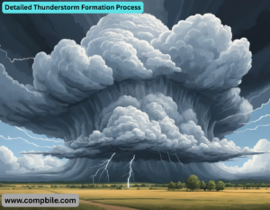
B. Stages of a Thunderstorm
- Thunderstorms go through three distinct life cycles:
- Cumulus (Developing) Stage
- Warm, moist air rises in an updraft.
- No precipitation yet (rain/hail is held aloft by strong updrafts).
Mature Stage
- The storm reaches its peak intensity.
- Heavy rain, hail, lightning, and gusty winds occur.
- Anvil cloud forms at the top as the storm hits the tropopause and spreads outward.
Dissipating Stage
- Downdrafts dominate, cutting off the storm’s updraft.
- Rain weakens, clouds evaporate, and the storm collapses.
Types of Thunderstorms
A. Single-Cell (Ordinary) Thunderstorms
- Short-lived (~30-60 mins), weak to moderate storms.
- Common in summer afternoons due to heating.
- Rarely severe, but can produce brief heavy rain and lightning.
B. Multi-Cell Cluster Thunderstorms
- Groups of storms in different life stages.
- Can last for hours, causing flash flooding due to repeated heavy rain.
C. Squall Lines
- Often form ahead of cold fronts.
- Produce damaging straight-line winds (derechos) and frequent lightning.
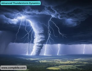
D. Supercell Thunderstorms
- The most dangerous type, with a rotating updraft (mesocyclone).
Can produce:
- Large hail (baseball-sized or larger)
- Tornadoes (especially strong, long-lived ones)
- Cause thunderstorms Extreme winds (over 100 mph)
- Often last for several hours due to organized structure.
Severe Thunderstorm Hazards
A. Lightning
- Caused by charge separation in clouds (positive top, negative bottom).
- Cloud-to-ground (CG) lightning is the most dangerous.
- Heat lightning is distant lightning without thunder (too far to hear).
B. Hail
- Forms in strong updrafts where raindrops freeze and grow in layers.
- Severe hail = 1 inch (quarter-sized) or larger.
C. Downbursts & Microbursts
- A sudden, violent downdraft of rain-cooled air.
- The Enhanced Fujita (EF) Scale rates tornado damage (EF0-EF5).
E. Flash Flooding
- The #1 thunderstorm killer (more deaths than lightning/tornadoes).
- Caused by slow-moving or training (repeated) thunderstorms.
How Meteorologists Predict Thunderstorms
A. Weather Radar (Doppler Radar)
- Detects precipitation, hail, and wind rotation (for tornadoes).
- Hook echo = possible tornado in a supercell.
B. Satellite Imagery
- Tracks cloud growth and storm movement.
C. Convective Available Potential Energy (CAPE)
- Measures atmospheric instability (higher CAPE = stronger storms).
D. Lifted Index (LI) & Wind Shear
- Negative LI = unstable air.
Notable Thunderstorm Events
- Derecho of 2012 – A 700-mile-long windstorm from Indiana to Virginia.
Advanced Thunderstorm Dynamics
A. The Role of Wind Shear
- Definition: Change in wind speed/direction with altitude.
Why it matters:
- 0-6 km shear > 35 knots → supercell development (rotating updrafts).
- Low-level shear (0-1 km) → tornadogenesis (tornado formation).
- Hodographs (wind profile plots) predict storm type:
- Straight-line hodograph → Multicell/squall line.
- Curved hodograph → Supercell potential.
B. CAPE (Convective Available Potential Energy)
- Measures instability (energy available for updrafts).
- < 1000 J/kg → Weak storms.
- 1000-2500 J/kg → Strong/severe storms.
- Cause thunderstorms > 3000 J/kg → Extreme supercells (giant hail, violent tornadoes).
- Inverted-V Soundings (steep lapse rates) = High CAPE, explosive storms.
C. Entrainment & Storm Efficiency
- Entrainment: Dry air mixing into updrafts → weakens storms.
- High CAPE + Low CIN (Convective Inhibition) = Most explosive storms.
Electrifying Details: Lightning Physics
A. Charge Separation Mechanism
- Inductive theory: External electric fields polarize particles.
- Result: Cloud becomes positively charged at top, negatively charged at base.
C. Thunder Generation
- Lightning heats air to ~30,000°C (5x hotter than the Sun’s surface) → rapid expansion → shockwave (thunder).
- Calculate distance: Time between lightning & thunder (seconds) ÷ 5 = miles away.
Extreme Thunderstorm Phenomena
A. Mesoscale Convective Systems (MCS)
- Size: 100+ km, lasts 6-12+ hours.
Features:
- Derechos – Widespread, long-lived windstorms (>58 mph gusts).
- Bow Echoes – Radar signature of intense straight-line winds.
B. HP (High-Precipitation) Supercells
- Rain-wrapped tornadoes (extremely dangerous for visibility).
- Cause thunderstorms Extreme hail (softball-sized or larger).
C. Landspouts & Gustnadoes
- Landspout: Weak tornado from non-supercell convection.
- Gustnado: Tornado-like vortex from outflow winds (not a true tornado).
Thunderstorms on Other Planets
- Venus: Sulfuric acid thunderstorms (no rain reaches surface).
- Jupiter: Ammonia-water storms (Great Red Spot is a mega-hurricane).
- Saturn: Hexagonal polar storm (mysterious 30,000-km-wide vortex).
Future Research & Climate Change Impacts
A. Climate Change Effects
- Warmer air = more moisture → stronger storms.
Projected changes:
- More intense rainfall (higher flood risk).
- Increased CAPE (potential for stronger supercells).
- Possible shift in tornado alley (eastward expansion).
B. New Forecasting Tech
- Phased-array radar (faster updates than Doppler).
- AI storm prediction (machine learning for tornado genesis).
- Lightning mapping arrays (3D tracking of discharges).
Bizarre & Rare Thunderstorm Events
- St. Elmo’s Fire – Glowing plasma from charged objects (ships, planes).
- Sprites & Jets – Upper-atmosphere electrical discharges (above storms).
- Volcanic Thunderstorms – Lightning in volcanic ash plumes.
The Quantum Mechanics of Thunderstorms
A. Ice Crystal Electrification: The Triboelectric Effect
- When graupel (soft hail) and ice crystals collide in updrafts, electrons shear off due to triboelectric charging (like rubbing a balloon on hair).
- Critical detail: Smaller ice crystals become positively charged, while larger graupel gains a negative charge. This separation powers lightning.
B. Gamma-Ray Flashes from Thunderstorms
- Cause thunderstorms Discovery: NASA satellites detected terrestrial gamma-ray flashes shooting upwards from storms.
- Cause: Strong electric fields accelerate electrons to near-light speed, which emit bremsstrahlung radiation (gamma rays) when they collide with air molecules.
- Implication: Thunderstorms are natural particle accelerators.
Chaos Theory & the Unpredictability of Storms
A. The Butterfly Effect in Storm Formation
- Tiny changes in humidity, temperature, or wind shear can radically alter a storm’s evolution.
- Example: A 1°C difference in surface heating can determine whether a supercell produces baseball hail or just rain.
B. Strange Attractors in Storm Trajectories
- Supercells sometimes follow chaotic, looping paths instead of straight lines.
- Mathematical models: Lorenz attractors (fractal chaos) can simulate storm motion.
C. The “Storm Collapse Paradox”
- Some storms suddenly dissipate despite high CAPE and shear.
- Hypothesis: Cold pools from downdrafts may strangle their own updrafts in a feedback loop.
Get article on pdf file….Click now
……..Cause thunderstorms…….